GOING FORWARD PHOTONIQUE WILL BE ADVERTISMENT FREE
GOING FORWARD PHOTONIQUE WILL BE ADVERTISMENT FREE
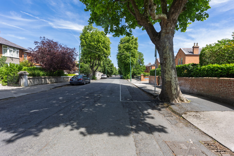
Originally Photographed 21 June 2026
UNFORTUNATELY GPS TRACKING FAILED
To understand Cowper Road, one must look at the names stamped across the local geography: Palmerston, Temple, and Cowper.
* In The Year 2008 * In The Year 2011 * In The Year 2017 * Henrietta Back In 2010
The Origin and History of Cowper Road
In the 18th and 19th centuries, much of the land in this part of Rathmines belonged to the Temple family. Henry John Temple, better known as the British Prime Minister Lord Palmerston, owned vast estates here. When his stepson, William Cowper (a prominent British Liberal politician), inherited the properties in 1869, he amended his surname to William Cowper-Temple (later 1st Baron Mount Temple). It is from him that Cowper Road takes its name.
The road was developed during the late-Victorian boom of the Rathmines Township (an independent local government district from 1847 to 1930). Wealthy Dublin merchants, professionals, and high-ranking civil servants fled the decaying inner city to build substantial, redbrick semi-detached and detached homes here.
Notable Highlights and Items of Interest
The peaceful, affluent lawns of Cowper Road mask a violent past. The entire area surrounding Cowper Road, Palmerston Park, and south toward the River Dodder was historically known as The Bloody Fields.
On 2 August 1649, during the English Civil War, the Battle of Rathmines raged across these lands. The Parliamentarian forces (Roundheads), led by Colonel Michael Jones, launched a surprise attack on the Royalist and Irish Confederate encampments led by the Duke of Ormonde. It resulted in a slaughter, with an estimated 2,000 to 5,000 men killed. Many of the dead are believed to be buried in mass graves directly beneath the foundations of the houses and roads in the area.
Perhaps the most striking architectural landmark on the road is the Mageough Home. Built in 1878, this beautiful redbrick complex features 39 Gothic Revival cottages, an infirmary, and its own central Church of Ireland chapel surrounding a manicured green.
The complex was funded by a massive bequest from Miss Elizabeth Mageough, who died in 1869. She left the modern equivalent of millions of euros to create a protected sanctuary for "aged females professing the Protestant faith." The land was purchased directly from William Cowper-Temple, and the complex remains an active, charming residential community today.
Detailing the Roads Off Cowper Road
Moving westward toward Upper Rathmines Road, several distinct side streets branch off Cowper Road, each with its own character:
Cowper Downs: A much more modern, quiet residential cul-de-sac winding away from the main thoroughfare. It features mid-to-late 20th-century developments that contrast with the Victorian redbricks, yet seamlessly blend into the mature greenery of the area.
Mageough Chapel Approach / Central Green: While not a public through-road, the internal avenues of the Mageough Home create a distinct, peaceful branch off the northern side of Cowper Road.
Palmerston Road: Intersecting near the western end, this is one of Dublin’s grandest Victorian avenues. The junction offers views of sweeping, highly decorated redbrick properties featuring distinct iron railings and immaculate granite steps.
Current Status
Today, Cowper Road is one of the most exclusive and expensive residential addresses in Dublin. Individual Victorian homes along the road routinely command prices between €1.5 million and upwards of €5 million.
The road has successfully maintained its architectural integrity, with the vast majority of its original Victorian facades, decorative brickwork, timber sash windows, and granite boundary walls strictly protected under Dublin City Council's Protected Structures legislation. It remains a tranquil, leafy canopy that bridges the quietude of high-end suburbia with the urban energy of Upper Rathmines Road.
After giving the matter a lot of thought I decided to go ahead with my visit to Belfast in the first week of July and I am now in the process of deciding what camera equipment to bring with me. Since I got the Sony A7RVI I have had problems with GPs - today it totally failed when using my iPhone XR which works perfectly with my A1 II and other Sony cameras. When I returned I decided to check if it worked with my iPhone 12 Pro Max and it did. I should mention that a very expensive CFexpress card (Euro 449) is giving problems in Slot A.
I was told that the 12 Pro Max with SIM was much less precise as a GPS source for my A7RVI.
So I decided to investigate and the answer is as follows:
The short answer is no, the tracking will not be less accurate purely because the iPhone 12 Pro Max lacks a SIM card. However, its real-world performance during a city trip will behave a bit differently than a phone with an active data connection.
Here is exactly how a SIM-less iPhone handles GPS tracking for a Sony A7R VI, along with why I might be experiencing that discrepancy between phones.
Smartphones contain a dedicated, hardware-based GPS receiver that communicates directly with overhead satellites. This chip does not require cellular signal, Wi-Fi, or a SIM card to calculate precise coordinates.
However, there is a catch regarding Assisted GPS (A-GPS):
With a SIM/Data: A phone uses cellular towers and Wi-Fi networks to instantly download satellite orbital data (Almanac and Ephemeris data). This allows the phone to get a location fix in seconds (known as a Time to First Fix, or TTFF).
Without a SIM: Because the iPhone 12 Pro Max cannot download this helper data on the move, it has to rely entirely on downloading the data directly from the satellites. This process is much slower and can take anywhere from a few minutes to a quarter of an hour if the phone has been completely off, restarted, or moved a long distance since its last sync.
The Precision Rule: Once the SIM-less iPhone does lock onto the satellites, its spatial accuracy (how precisely it pins one to a street corner) is identical to a phone with a SIM. The iPhone 12 Pro Max also supports multiple global satellite systems (GPS, GLONASS, Galileo, QZSS, and BeiDou), giving it excellent standalone tracking capability.
The failure on my iPhone XR versus the success on the iPhone 12 Pro Max with the A7R VI likely comes down to two specific hardware and software factors:
Bluetooth Architecture: The Sony A7R VI relies on the Sony Creators' App via Bluetooth Low Energy (BLE) to constantly pull location data in the background. The iPhone 12 Pro Max features a newer, more robust Bluetooth 5.0 chipset and a faster processor compared to the older XR. If the XR's background processing was lagging or its Bluetooth stack choked on the A7R VI's specific handshake, the connection would drop.
iOS 27 Beta Background Handling: Since my devices are running the developer betas, background location daemon stability can be unpredictable. iOS betas frequently adjust energy-saving profiles, often aggressively killing background apps (like the Creators' App) on devices with less RAM (the XR has 3GB; the 12 Pro Max has 6GB). The extra headroom on the 12 Pro Max is likely keeping the background sync alive.
To ensure the iPhone 12 Pro Max tracks urban routes flawlessly without a SIM, use this workflow:
Pre-Cache the GPS Almanac: Before leaving my accommodation (while connected to Wi-Fi), open the Apple Maps or Google Maps app on the iPhone 12 Pro Max. This forces the phone to download the latest A-GPS data over Wi-Fi, ensuring instant satellite locks once you step outside.
Download Offline Maps: In Google Maps, download the entire Belfast city area for offline use. Even though the Creators' App just sends coordinates to the camera, having offline maps cached on the phone helps the OS stabilise its location services when cellular triangulation isn't available.
Lock the Creators' App in Focus: Make sure the Creators' App is set to Location Information Linkage -> ON. Keep the app running in the background and ensure "Background App Refresh" is enabled for it in iOS settings. Given the beta software, it's good practice to glance at the camera's display occasionally to ensure the little GPS icon is solid and not flashing.
* February 2026: High Resolution Images * April 2026: High Resolution Images * May 2026: High Resolution Images