MY SECOND TIME TO EXPLORE MILL ROAD
Exploring Mill Road in Limerick - From Suburban Bastion to Riparian Haven
A previous visit to Limerick in July 2025 had been marred by relentless rain, thwarting my plans to explore the banks of the River Shannon. Returning in October 2026 for a four-night stay, I arrived prepared for the worst of the elements. Fortune was on my side: the autumn weather proved remarkably mild and clear, save for a sudden cloudburst during an excursion to the University of Limerick campus.
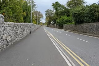
Mill Road in Corbally presents an intriguing study in suburban seclusion, architectural transition, and infrastructural modernisation. Extending roughly 1.4 kilometres from its southern junction with the R463 Corbally Road down to the Shannon’s edge, the route behaves less like a standard thoroughfare and more like an elongated, fortified residential corridor that gently dissolves into a tranquil riparian lane.
The Fortified Southern Gateway
At its southern, city-facing approach, Mill Road is framed to the east by the expansive grounds of Scoil Íde and St Munchin’s College. In stark contrast to these open educational campuses, the western side is dominated by deep, historic villa plots and substantial twentieth-century detached homes.
The dominant architectural tone here is one of defensive verticality:
Imposing Boundary Walls: Towering, finely coursed limestone walls—finished with substantial coping stones and bolstered by dense evergreen hedging—line the roadway, firmly cutting off any line of sight to the houses concealed within.
Active Travel Upgrades and Infill Schemes: The semi-industrial character evident along sections of this stretch is the result of major civil engineering and active travel improvements running parallel to private residential development. High-end infill projects, notably around Laurelville, necessitated significant boundary realignment. Meanwhile, municipal excavations for drainage, services, and shared walking and cycle routes transformed verges into worksites. Traditional lime mortar was used to rebuild the premium limestone walls, momentarily giving parts of the corridor the austere feel of a working quarry.
Commercial Absence and the Meadowbrook Enclave
North of the schools, Mill Road settles into a near-total absence of enterprise. There are no pubs, cafés, or corner garages; commerce remains firmly anchored to the R463 artery.
The only departure from this purely domestic landscape sits halfway along the route, near the Meadowbrook junction. Here stands a modest commercial building that once catered to immediate neighbourhood needs—first operating as a local corner shop, and later housing boutique salon and agency services. Today it sits shuttered and quiet, its blank frontage underscoring the reality that commercial trade struggles to gain a foothold along this strictly residential spine.
The Northward Transition
Past the turn-offs for Meadowbrook and Riverbank, the road undergoes a notable deceleration in scale, geometry, and atmosphere:
Roadway Compression: The wide carriageway and freshly engineered margins steadily narrow. Tarmac kerbing yields to soft earthen verges, drainage ditches, and encroaching hedgerows, with mature horse chestnuts, beeches, and sycamores closing in to form a dense canopy.
Eclectic Domestic Styles: The grand, gated perimeter walls of the southern stretch give way to mid-century ribbon bungalows and mid-density developments, before yielding to striking bespoke homes near the river. Modern properties clad in crisp white render, zinc, and cedar stand cheek-by-jowl with historic cottages and weathered agricultural holdings.
Terminus on the Shannon
In its final hundred metres, Mill Road sheds its suburban reserve. Dwellings angle back from the carriageway to accommodate the natural floodplain, and the roadway terminates at an open cul-de-sac and grassy riverbank turnaround known locally as The Green.
At this boundary, the engineered landscape surrenders entirely to the river:
The Fairy Garden Threshold: Where the road ends, a steep, willow-clad slope drops toward the water, home to the community-crafted Mill Road Fairy Garden with its miniature painted stones and doors set into the bark. As local children were playing nearby, I refrained from taking photographs of the installation.
The Shannon Panorama: Here, the Shannon opens out in a wide, tidal sweep. Across the water lie the green margins of Shannon Banks and County Clare, while upstream the flow parts around St Thomas’ Island, where shallow gravel shoals recall the ancient fishing channels of the historic Lax Weir.
The River Path Trailhead: This tranquil terminus doubles as an active walking node. Pedestrians can strike out east along the paved riverside embankment known as the Red Path toward Athlunkard Bridge, or follow the sheltered inland footpath alongside the stream leading toward the historic site of the old Corbally Baths.